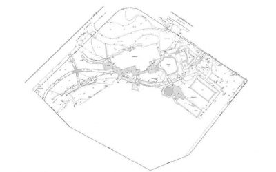
Drone Topographic Survey is necessary to determine the aerial layout of any project. Latest equipment including cameras and sensors are used to capture images at the different light spectrum, which helps to create an aerial drone map of the project. The drone maps are created for suitable industrial uses which involves images in Infrared as well as visible spectrum of light. Usually, NIR (Near Infrared) cameras are used to account for the growth of any vegetation or fungus in the area of construction. Visible images or RGB are used for surveying and mapping purposes with the help of latest software.
At ArcVertex, we provide the clients with the best drone surveying and survey CAD drafting services to improve the overall quality of the project. These days’ drones are helping people to map large areas in a quick, cost-effective manner and to provide hard data that helps hasten workflows in a variety of commercial settings. We provide regular updates to the clients through the maps created by our experts which will help them to better understand the progress of the project. The Drones are designed to access all the flight information apart from the images captured, which helps to get high-quality images from optimum distances. It flies automatically and returns back when all the portions of the project are covered.
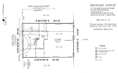
Drone and Arial Mapping Includes
- 100% Accurate Linework/ Mapping
- Keep all Client's Standards
- Rectify Boundaries
- Tables & Blocks Creation
- Zoning & Labeling
- Easements & Utility Mapping
Other ArcVertex's Services
How It Works
Fast Delivery | High Quality
Upload Your File
Our Experts at Work
Revision If Required
Delivery Within 24Hrs*
- At ArcVertex, you can find the best, efficient, knowledgeable and complete result of your ideas.
- We provide best Drone mapping services for the betterment of the project during the development phase.
- We use latest equipment and software to provide accurate and detailed results.
- Our experts have years of experience in providing Drone and Aerial Mapping Services.